
Discover an unparalleled cycling challenge: 900km, 8 days, 21,600m of positive elevation gain and the amazing beauty of the Canary Islands by road bike. Embark on this exciting journey through unique landscapes and enjoy the best weather. Want to see what we're talking about? In early October 2023, the cyclists Pol Tarrés and Lina Bo completed the 8 Islands Cycling Challenge. Ready yourself for an unparalleled cycling adventure in the middle of the Atlantic!
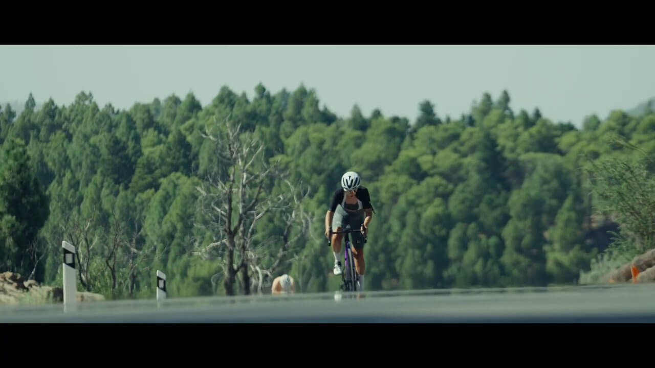
Crossing the Canary Islands by Bike. Have you ever thought about it? Imagine challenging yourself to an unparalleled feat through the eight Canary Islands, a unique territory full of contrasts and amazing landscapes that has the privilege of having the best climate in the world during the European winter. This means being able to ride in ideal conditions, without worrying about extreme cold or inclement weather, allowing you to explore the breathtaking beauty of the Canary Islands while enjoying mild, sunny temperatures.
Embark on a unique adventure of 900km and more than 21,600m of positive elevation gain. From La Palma to La Graciosa in 8 days. You will absorb the history, culture and natural beauty of each island. You will enjoy a cycling experience that will challenge your physical limits, but will also leave you in awe of the diversity and attractiveness of the Canary Islands, from magical lush forests to breathtaking volcanic terrain.
Get ready for an exciting and extreme bike ride full of challenges and rewards in this mid-Atlantic cycling paradise.

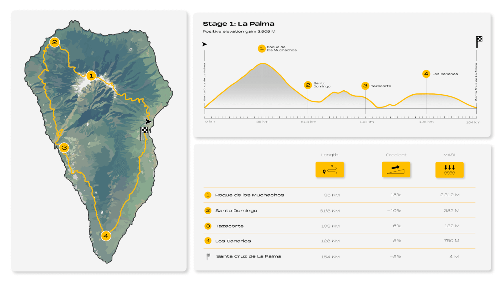
Stage 1: La Palma, la Isla Bonita
Santa Cruz de la Palma – Roque de los Muchachos – Santo Domingo – Tazacorte – Los Canarios – Santa Cruz de la Palma
- Kilometers: 154km
- Estimated time: 7.30 hours
- Highest point: 2.312m of altitude
- Positive elevation gain 3.909m
If La Palma were a color, it would be green, in all its range of shades. It is that of the Canary Island pines, and also the green of the different species of laurel forests that have taken refuge on the Isla Bonita.
The capital, Santa Cruz de la Palma, marks the beginning and end of a 154km journey that covers almost the entire island. From the capital of La Palma to the Roque de los Muchachos, then on to Santo Domingo, down to Tazacorte and on to Los Canarios, the highest area in the south of the island. And from there, back to Santa Cruz de La Palma.
The adventure to the Roque de los Muchachos, the highest point of the route and of the island, begins at the marina of La Palma, in Santa Cruz, near the historic center of the capital. Ahead, the longest climb of the entire challenge, 32km with 2,400m of elevation gain. This is an exciting but challenging climb with ramps of up to 16% gradient that will test your endurance and cycling skills.
We are talking about one of the toughest routes for cycling lovers, but also one of the most emblematic. The landscape changes completely during the ascent, going from lush pine forests to spectacular volcanic landscapes, with unique rock formations and impressive craters. And once at the top await the breathtaking views of the National Park of La Caldera de Taburiente, the most representative natural wonder of La Palma.
The route then descends to Santo Domingo, the municipal capital of Garafía, and one of the most picturesque corners of the island. From this point, the route heads towards Tijarafe and Tazacorte, at km 104. Be prepared for the last climbs of the day up to Jedey. Despite the profile, although very short, they are very tough. The subsequent descent is a treat for cyclists. Tijarafe, about 640m above sea level, offers panoramic views to remember and passing through Tazacorte you can admire its black sand beaches.
A gentle ascent of about two hours leads to the highest area south of La Palma, Los Canarios. Located at 750m, this landscape is marked by the impressive Teneguía volcano, the lighthouse and the salt flats of Fuencaliente. And from there, to the starting point, Santa Cruz de La Palma. A final route between houses of just over an hour to enjoy the scenery of the east coast of La Palma before reaching the finish line.

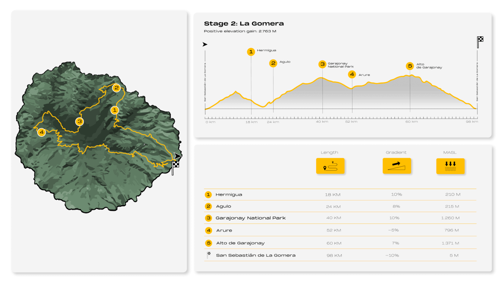
Stage 2: La Gomera, Enter into its Magic
San Sebastián de La Gomera – Hermigua – Agulo – Parque Nacional de Garajonay – Arure – Alto del Garajonay – San Sebastián de La Gomera
- Kilometers: 98km
- Estimated time: 5.30 hours
- Highest point: 1,363m of altitude
- Positive elevation gain: 2.763m
San Sebastian is the chosen starting point to travel through the heart of La Gomera, a 98km-route marked by lush laurel forests, deep ravines and steep cliffs, imposing rocks, valleys colonized by lush palm groves, small wild beaches...so are the landscapes of La Gomera.
The adventure begins in the capital and is marked by a beautiful and gradual ascent on the way to Las Poyatas. The arid landscape that accompanies this first challenge changes for a green and lush one when crossing the tunnel that leads to the valley of Hermigua. From there you will need about 30 minutes heading north to reach Agulo, a charming village of cobblestone streets and restored houses, also known as "The bonbon of La Gomera." On the way you will find ramps of up to 16% slope at some points that will test your physical condition. But the effort will pay off. An immense viewpoint over the Atlantic Ocean awaits you, tinged by the green of its crops.
And from there to the impressive Garajonay National Park, a natural treasure declared a World Heritage Site by UNESCO. A constant but moderate slope of about 800m will lead you to the interior of the dense and well known laurel forests. It is worth not missing out on any detail, because as you go along the road, you will be immersed in a magical, mysterious and humid atmosphere.
The route continues with a pleasant descent to Arure, a village in the upper part of the Valle Gran Rey ravine that conceals another of the charms of La Gomera: The Arure Waterfall, a must-see if you have enough time. And once there you have to gather strength to face the Alto de Garajonay.
The more daring cyclists will enjoy an epic climb with long ascents and steep gradients, sometimes over 10% elevation gain. You will reach 1300m, the highest point of this route, which will allow you to admire incredible views to remember. You will cross the villages of Las Hayas, El Cercado and Temocodá, where you can stop to recharge your batteries, eat something and refill your water bottles. It should be noted that from this point to the end of the route you will only find a bar-restaurant located next to the Degollada de Peraza Viewpoint.
The only thing left to do then is to enjoy what has been achieved in a pleasant descent of about 26km toward the capital, where the final point of the adventure in La Gomera is located.

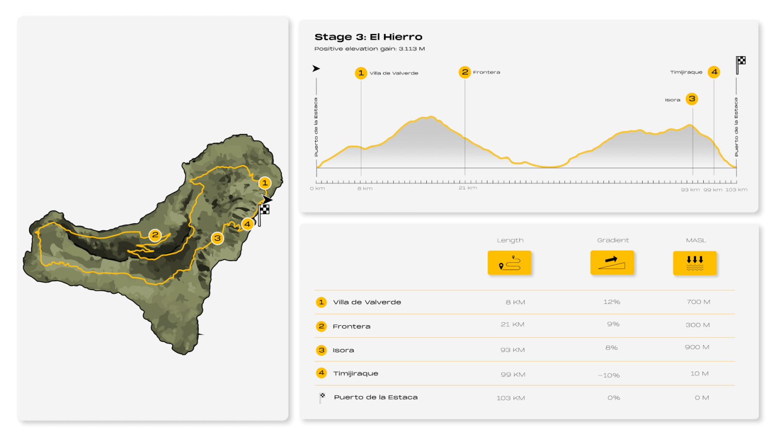
Stage 3: El Hierro, Explore the Island with Soul
Puerto de la Estaca – Villa de Valverde – Frontera – Isora – Timijiraque – Puerto de la Estaca
- Kilometers: 103km
- Estimated time: 6 hours
- Highest point: 1.341m of altitude
- Positive elevation gain: 3.113m
Can an island have a soul? To answer this question you have to go to El Hierro, the youngest of the Canary Islands. It is difficult to explain the magic of this small Atlantic and volcanic island, a corner of calm and tranquility to forget the rush and stress that you will discover during the more than 100km of travel.
Just over 14km separate Puerto de la Estaca, the starting point of the adventure in El Hierro, from Villa de Valverde, in the northwest, the capital of the island and first destination of this route. With its volcanic landscapes, lush nature and spectacular views of the Atlantic Ocean at almost every turn, this cycling paradise will take your breath away from the start. So will its slope.
The first part of the route to reach the village of Valverde will be along an 8km pass, through gentle curves and moderate slopes, perfect for warming up the muscles in the first kilometers of the route. You will find two villages in the next 4km, El Mocanal and Guarazcoa, where we recommend making the first stop of the day, because until Tingaday, 32km later, you will not have the opportunity to refuel again.
What follows will be the most complicated point of the route in El Hierro. To get to Frontera from the capital of the island, besides being amazed by the views of the El Golfo Valley from La Peña Viewpoint, you will have to conquer the more than 1,300m above sea level of the surroundings of the Tenerista peak. The sections with more than 12% of slope will be rewarded with a pleasant descent flanked by some astonishing panoramic views.
The return to the island from the meridian continues along the coast until reaching the northeastern tip of El Hierro, almost at the northernmost point of the Iberian Peninsula. After admiring the iconic wind-twisted junipers, you will begin an ascent of about two and a half hours. You will go around the Tenaca, Tembárgena and Tomillar mountains as well as the Montañita del Guanche de Arriba to face a climb up to 1,100m above sea level towards Isora, a place to recharge your batteries and fill up with energy.
From there, about 8km downhill will separate you from Timijiraque, where nature lovers will enjoy its practically virgin beach. The next stop will be Puerto de la Estaca again, the end of a wonderful route through an enigmatic island, wrapped in a halo of mysticism and that, in its day, marked the end of the known world.

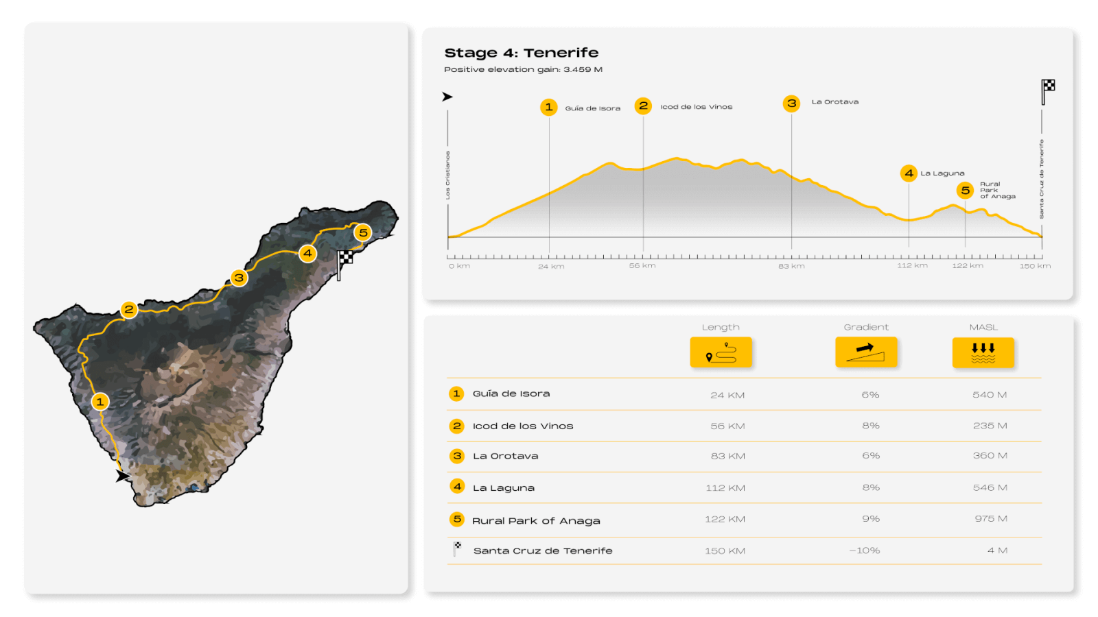
Stage 4: Tenerife, Challenging the Epic
Los Cristianos – Guía de Isora – Icod de los Vinos – La Orotava – La Laguna – Parque Rural de Anaga – Santa Cruz de Tenerife
- Kilometers: 150km
- Estimated time: 7 hours
- Highest point: 1.143m of altitude
- positive elevation gain: 3.459m
Tenerife is an island of a thousand experiences. A thousand plans that are possible at any time of the year thanks to the mild climate and the wide range of activities offered by the largest of the Canary Islands.
The route in Tenerife, one of the most demanding, has its starting point in the southwest of the island, in Los Cristianos, a coastal town known for its characteristic maritime energy. This is the beginning of a 150km route full of points to recover strength, as demanding as it is incredible in the north of the largest of the Canary Islands, the fetish island for professional cyclists due to its diversity of terrain, its orography and its altitude, fundamental for training at altitude and to take performance to the highest level.
A pleasant walk of about 12km will take you to the quiet town of Adeje, your first objective, where you can begin to get an idea of the panoramic views of the Atlantic Ocean that will accompany you along the way.
The terrain will begin to challenge your legs as you approach Guía de Isora, with slopes of between 5% and 7% gradient, reaching 600m above sea level. Behind you will be arid landscapes. From then on, you will be immersed in abundant vegetation and embark on one of the most popular stretches for the pros.
After 5km you will reach Chío, a mandatory stop for Movistar cyclist Annemiek Van Vleuten during her training in Tenerife. You will need to complete another demanding 8km section that will take you to Santiago del Teide, at 930m above sea level. From there, you will enjoy a variety of emotions in the direction of El Tanque and Mirabal, with technical descents and climbs that will test your endurance. However, you will soon be rewarded with the descent to Icod de los Vinos, where you will be able to contemplate, if you feel like it, the famous Drago Milenario.
The route continues downhill to almost sea level, through San Juan de la Rambla and Los Realejos, setting a course for Puerto de la Cruz, in the north of Tenerife. It is the perfect place to catch your breath before returning to face the slopes of the 20km that separate this well-known town from Tacoronte, the next point of the route. And from there to La Laguna, a UNESCO World Heritage City, which will serve as a prelude to the challenge of the Anaga Rural Park.
A massif of sharp-edged mountains and deep ravines covered with a green blanket of laurel forest dotted with charming hamlets is what awaits you as you enter Anaga. Get ready for 30km of demanding climbs, some over 12% elevation gain, but also for unparalleled panoramas of ancient forests and rugged mountains.
When you reach El Bailadero, all you have to do is let yourself go. There you will begin a dizzying descent towards San Andrés before concluding your epic journey in the capital, Santa Cruz de Tenerife.

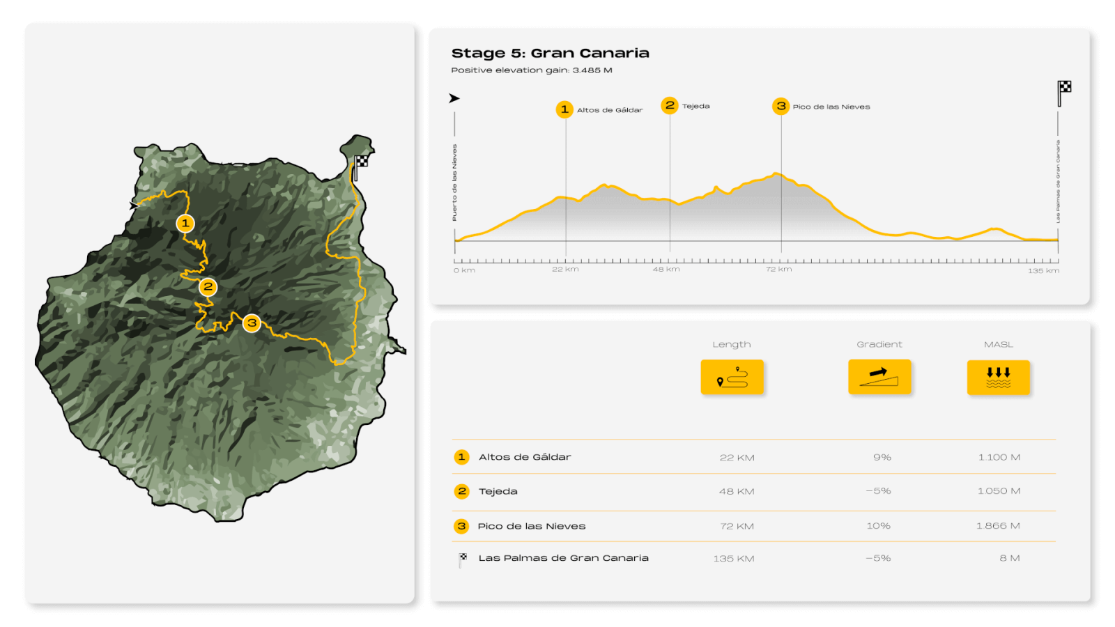
Stage 5: Gran Canaria, an Adventure Through a Miniature Continent
Puerto de las Nieves – Altos de Gáldar – Tejeda – Pico de las Nieves – Las Palmas de Gran Canaria
- Kilometers: 135km
- Estimated time: 7 hours
- Highest point: 1.861m of altitude
- Positive elevation gain: 3.485m
In the fishing village of Puerto de las Nieves begins a journey of more than 8 hours through Gran Canaria, also known as "the miniature continent" for its marked contrasts. In the same day we can enjoy wonderful beaches surrounded by dune fields and climb to the summits covered by Canary pine forests, whose greenery stands out in the dark volcanic substrate. Get ready to enjoy its rich nature and scenic diversity, as well as its culture and history, from Agaete to Las Palmas de Gran Canaria.
On this occasion, the challenge starts upon departure. More than 32km in progressive ascent, with a small stretch of 4km downhill in the middle towards the interior of the island, through the area of the Altos de Gáldar, will take you to find the first rest area for your legs. You will be at 1,200m above sea level and you will have left behind small towns like Tegueste or Fagajesto, where you will be grateful to stop. After a short break you will face the second peak of the route, this time of more than 1500m with ramps of up to 10% slope that will take you to the Mirador de Pinos de Gáldar, where you can enjoy a wide panoramic view of the north and west of Gran Canaria.
On the descent that follows you will pass through Tejeda, a must-see village framed in a landscape of ravines and in the shadow of Roque Nublo, one of the largest natural crags in the world. This volcanic rock rises eighty meters above its base and 1,813m above the sea. Its enormous presence is only surpassed in height by the Pico de Las Nieves, with 1,949m, the highest place in Gran Canaria and the next objective of the route, the hardest mountain pass in Europe.
A climb of more than 10km with 1,585m of positive elevation gain and ramps of up to 23% will take you to the top of the peak of Las Nieves, the highest point of the route. Get ready to enjoy the show. You will have before you the vast area of the island declared a Biosphere Reserve by UNESCO.
After this achievement, reserved for only a few, you will enjoy a steep descent to La Pasadilla through the Los Marteles Special Nature Reserve. You will go down to 200m and reach Ingenio to head towards Las Palmas de Gran Canaria, the end of the route, in a pleasant walk that will allow you to admire the beauty and history of towns such as Telde, the oldest city on the island.

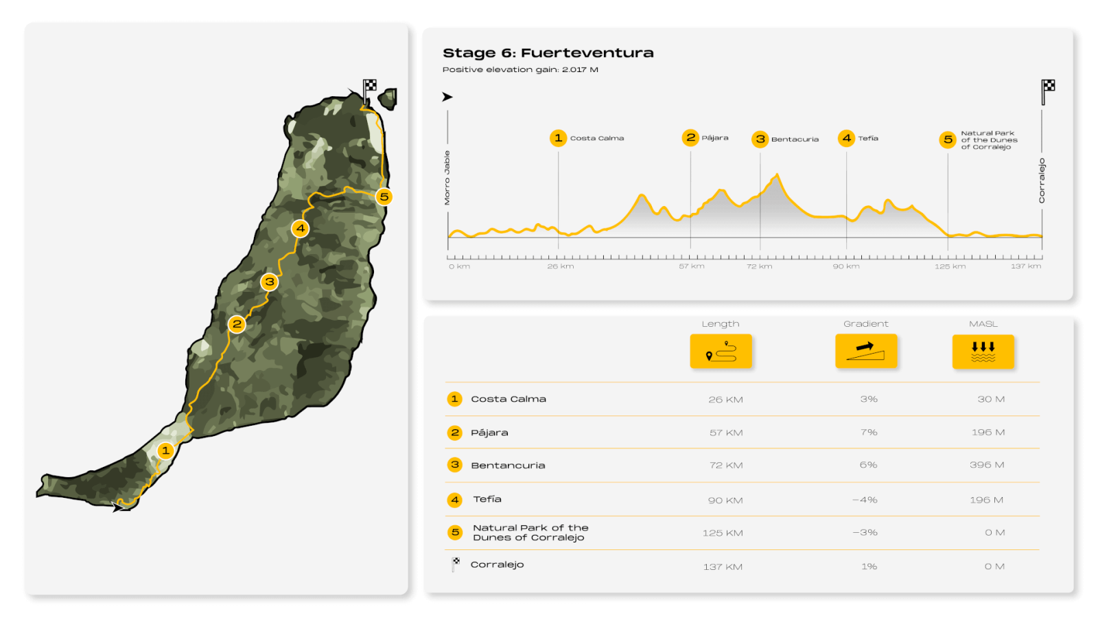
Stage 6: Fuerteventura, a Challenge in Paradise
Morro Jable – Costa Calma – Pájara – Betancuria – Tefía – Parque Natural de las Dunas de Corralejo
- Kilometers: 137km
- Estimated time: 6 hours
- Highest point: 586m of altitude
- Positive elevation gain: 2.017m
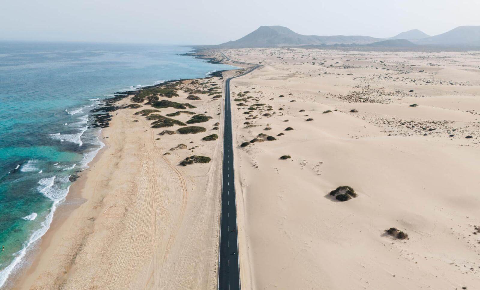
The port of the fishing village of Morro Jable, the southernmost tourist town of Fuerteventura, marks the start of this route, a journey of contrasts of just over 6 hours along one of the jewels of the Canary Islands. Fuerteventura is synonymous with miles of paradisal beaches of white or golden sand and turquoise waters, an idyllic island for anyone who likes to feel the sun, the sea breeze and take revitalizing baths in calm and transparent waters.
The crossing of Fuerteventura starts on a very smooth road north along the coast, next to the Natural Park of Jandia in the direction of Costa Calma, the gateway to the paradisiacal beaches of Sotavento. A pleasant drive of less than 1 hour overlooking the Atlantic Ocean where it is advisable to stop, because when leaving behind the oasis in the middle of the arid landscape of Costa Calma, the terrain begins to be challenging. On the way to Pájara, where you will not find any services, the slope increases to about400m above sea level and it’s in this section where you will find the highest slope of the route, approximately 8%.
Betancuria, the least populated municipality of the island, is the next destination, the highest of the adventure. It is necessary to climb to more than 600m to conquer the Morro de la Cruz. However, from there you will enjoy an exciting descent that your legs will appreciate toward the Santa Inés Valley and Llanos de la Concepción in the direction of Tefía of about 17km until you face the last slope of the route.
At this point the route heads back towards the coast, towards the Natural Park of Corralejo Dunes, the ideal place to enjoy the desert beauty of the island of Fuerteventura. This 10.5km coastal strip has two harmoniously contrasting sectors. In the south, the landscape is volcanic, with ochre and red colors, rough and dramatic shapes. In the north, next to the tourist center of Corralejo, the last stop of the tour, is the largest dune field in the Canary Islands, a huge expanse of white sand bathed by the turquoise waters of the Atlantic Ocean, the best place to enjoy the end of the adventure in Fuerteventura.

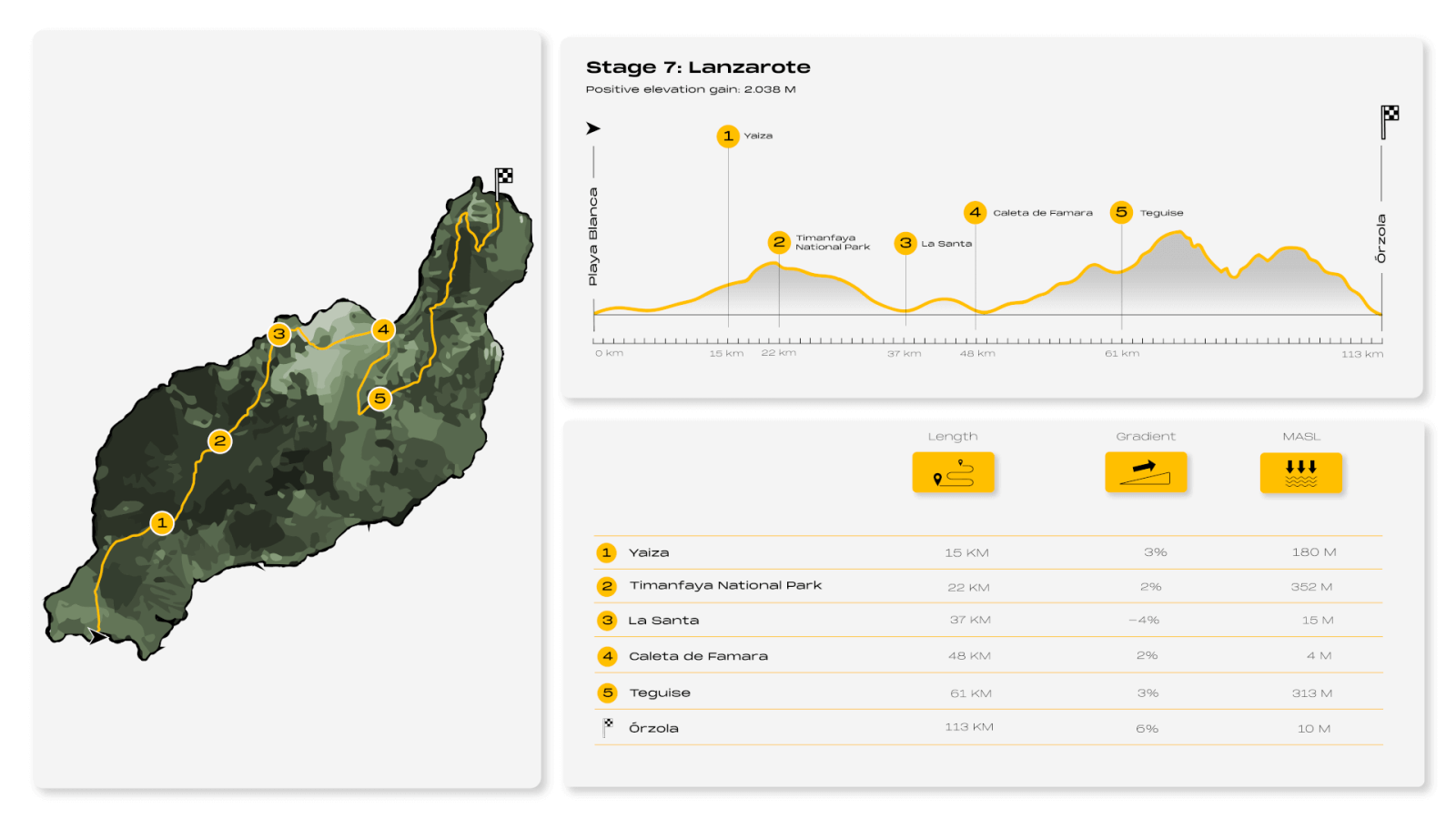
Stage7: Lanzarote, Through Volcanic Essence
Playa Blanca – Yaiza – Parque Nacional de Timanfaya – La Santa – Caleta de Famara – Teguise - Órzola
- Kilometers: 113km
- Estimated time: 5.45 horas
- Highest point: 569m of altitud
- Positive elevation gain: 2.038m
Lanzarote is synonymous with volcanoes, lava fields, black and reddish earth that contrasts with the white of the houses, the blue of the ocean and the blue of the sky. The characteristic landscape of the easternmost of the Canary Islands is the protagonist of this route, which begins its journey in the south and whose objective is to reach Órzola, at the other end.
The adventure, which lasts about 5 hours, departs from the marina of Playa Blanca and heads towards Yaiza, one of the most emblematic villages of Lanzarote. This is a pleasant first stretch of approximately 50 minutes that starts on the flat and allows you to admire the wonderful landscape formed by the Janubio salt flats, the largest in the Canary Islands. Once past the viewpoint of the same name, you will notice how the terrain begins to slope slightly to reach 340m above sea level in the Natural Park of the Volcanoes, which offers a breathtaking landscape resulting from the last volcanic eruption of the island.
You will need about 20 minutes of descent to reach Tinajo and return to sea level at La Santa, on the northwest coast of the island, one of the favorite spots for surf lovers. The route continues to Caleta de Famara, a small town belonging to Chinijo Natural Park. You won't need to get off the bike to admire the spectacular Risco de Famara. And from there to Teguise where you will face the hardest part of the route.
You will face a route of about 25km, approximately 1 hour and a half, uphill, with ramps in some cases up to 9% slope in the final part to reach 569m altitude, the highest peak of the adventure. Among the mountains, in the shadow of the volcano of La Corona Natural Monument, you will find Haría, an oasis in the middle of the pure geology of the island located in one of the best palm groves of the Canary Islands.
About 30 minutes, downhill from Máguez, it will take you to reach Río Viewpoint, 500m above sea level, the last peak on this route. From there, you will be able to observe the Chinijo archipelago with the island of La Graciosa as the main attraction. We are talking about a spectacular image that will accompany you until the final descent of the challenge, of 11km, in Puerto de Órzola, where you will be able to contemplate a spectacular sunset.
Active Recovery: La Graciosa
Protected as a natural park, La Graciosa, the largest and only inhabited of the islands of the Chinijo archipelago, located north of Lanzarote, is the ideal place to recover your energy after the challenge.
Small, quiet, without asphalt or pollution, enveloped in virgin nature, surrounded by paradisal beaches of turquoise waters and white sand. This is La Graciosa, the smallest of the 8 islands and the last stop of this adventure, the ideal place to take a breath of fresh air, rest and enjoy the healthy properties offered by the archipelago.
The hours of sunshine, the composition of the marine waters and the materials of volcanic origin that the Canary Islands possess are highly beneficial in recovery therapies. It has been proven that the body, after being exposed to the sun, generates vitamin D and secretes serotonin, a hormone related to emotional well-being. In addition, bathing in the sea, which contains more than 80 components present in our body, helps eliminate toxins.
It is for this reason that La Graciosa, the largest marine reserve in the European Union, will be a dream come true in your quest for relaxation and absolute connection with the environment after the feat achieved.
